Copyright © 2008, 2009, 2011, 2012, 2014 Steffen Macke
Dieses Dokument wurde unter der GNU-Lizenz für freie Dokumentation veröffentlicht.
Es ist erlaubt, das Bild zu kopieren, verbreiten und/oder zu modifizieren, unter den Bedingungen der GNU-Lizenz für freie Dokumentation, Version 1.2 oder einer späteren Version, veröffentlicht von der Free Software Foundation.
Die Free Software Foundation stellt eine Kopie der Lizenz zur Verfügung: http://www.gnu.org/licenses/fdl.html
$Date 2014-01-28$
Inhaltsverzeichnis
Inhaltsverzeichnis
Inptools sind Werkzeuge, um Dateien im EPANET INP Format zu bearbeiten.
Inptools sind erhältlich unter epanet.de/inptools .
Dieses Handbuch beschreibt die Version 1.0.1 der Inptools.
Ein Zusammenfassung der Änderungen.
Explorer-Integration für inp2shp. Nutzen Sie das Explorer-Kontextmenü, um aus INP-Dateien Shapefiles zu erzeugen.
Mehrerer Fehler in der inp2shp-Anwendung wurden behoben.
Die ersten drei Zahlen der Versionsnummer entsprechen jetzt denen der im Windows-Installationspaket enthaltenen EPANET-Version.
Fehlerkorrektur bei der Erzeugung von CSV-Dateien: Der Dateiname "node.csv" wurde für Leitungsdaten angeboten.
EPANET 2.0.0.12 wurde zusammen mit der Dokumentation zum Installationsprogramm hinzugefügt.
Die Windows-Version erfordert mindestens Windows 7.
Verbesserte Windows-Explorer-Integration: Ein Doppelklick auf *.net und *.inp-Dateien öffnet diese in epanet2w.
Das Kontextmü im Windows Explorer wurde um die Funktionen "CSV Ergebnisdatei erstellen", "binäre Ergebnisdatei erstellen" und "Hilfe" erweitert.
Das Programm epanet2csv wurde ins Paket aufgenommen.
Linux oder Windows (7, 8, 8.1 oder neuer) werden benötigt, um die Inptools-Software zu nutzen.
Inptools 0.2.3 ist die letzte Version, die ältere Windows-Versionen unterstützt.
Wie die Inptools-Software installiert wird.
Wie die Inptools unter Windows installiert werden.
Laden Sie das Installationsprogramm von epanet.de/inptools herunter und führen Sie es aus.
Wie die Inptools unter Linux installiert werden können.
Laden Sie das RPM-Paket von epanet.de/inptools herunter und installieren Sie es.
Inhaltsverzeichnis
Inptools können über ein Kontextmenü im Windows Explorer oder über die Kommandozeile genutzt werden.
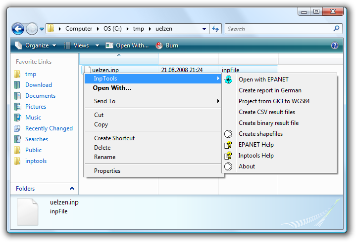
Windows Explorer Integration
Öffnen Sie den Windows Explorer.
Navigieren Sie zu einer Datei im INP-Format.
Klicken Sie mit der rechten Maustaste auf die INP-Datei.
Wählen Sie das Inptools-Menü.
Wählen Sie → , um die gewählte INP-Datei in epanet2w interaktiv zu bearbeiten.
Diese Option steht nur zur Verfügung, wenn EPANET installiert ist.
Wählen Sie → , um aus der gewählten INP-Datei einen Berechnungsbericht in deutscher Sprache zu erstellen.
Wählen Sie → , um die gewählte INP-Datei mit mit Gauß-Krüger Koordinaten (GK3) in eine neue INP-Datei mit geographischen (WGS84) Koordinaten zu konvertieren (projezieren).
Wählen Sie → , um aus der gewählten INP-Datei zwei CSV-Dateien mit den Berechnungsergebnissen zu erzeugen. Eine Datei wird Knotenergebnisse enthalten, die andere Leitungsergebnisse.
Wählen Sie → , um aus der gewählten INP-Datei einen Berechnungsbericht und eine binäre Ergebnisdatei zu erzeugen. Die binäre Ergebnisdatei kann beispielsweise mit dem Kommandozeilenwerkzeug epanet2csv weiterverarbeitet werden.
Wählen Sie → , um aus der gewählten INP-Datei mehrere Shapefiles (Knoten, Leitungen, Pumpen, Tanks, Reservoirs) zu erzeugen.
Die erzeugten Shapefiles können mit entsprechender GIS-Software (wie beispielsweise QGIS) geöffnet werden. Falls Sie QGIS nutzen, könnte Sie das Plugin "GHydraulics" interessieren.
Das Inptools-Paket enthält mehrere Kommandozeilenwerkzeuge.
![[Anmerkung]](images/note.png) | Anmerkung |
|---|---|
Die Nutzung der Kommandozeilenwerkzeuge ist optional für Windows-Nutzer. Falls ihnen die Kommandozeile unbekannt ist, sollten sie statt dessen das Kontextmenü des Windows Explorers ( „Windows Explorer Integration“ ). |
Der Befehl inpproj konvertiert (projeziert) eine INP-Datei mit Gauß-Krüger Koordinaten (GK3) in eine neue INP-Datei mit geographischen (WGS84) Koordinaten.
epanet2l ist eine modifizierte (lokalisierte) Version von epanet2d, die es erlaubt, Berichte in deutscher Sprache zu erzeugen.
Die LANG-Umgebungsvariable zur Konfiguration der
epanet2l-Sprache genutzt werden.
Inptools Tools to work with EPANET INP files.
Copyright (C) 2001, 2008, 2009, 2011 Steffen Macke
This program is free software; you can redistribute it and/or modify it under the terms of the GNU General Public License as published by the Free Software Foundation; either version 3 of the License, or (at your option) any later version.
This program is distributed in the hope that it will be useful, but WITHOUT ANY WARRANTY; without even the implied warranty of MERCHANTABILITY or FITNESS FOR A PARTICULAR PURPOSE. See the GNU General Public License for more details.
You should have received a copy of the GNU General Public License along with this program; if not, see http://www.gnu.org/licenses/.
The inp2shp and shp2inp commands use shapelib under the terms of the LGPL.
Copyright (c) 1999, Frank Warmerdam
This software is available under the following "MIT Style" license, or at the option of the licensee under the LGPL (see LICENSE.LGPL). This option is discussed in more detail in shapelib.html
Permission is hereby granted, free of charge, to any person obtaining a copy of this software and associated documentation files (the "Software"), to deal in the Software without restriction, including without limitation the rights to use, copy, modify, merge, publish, distribute, sublicense, and/or sell copies of the Software, and to permit persons to whom the Software is furnished to do so, subject to the following conditions:
The above copyright notice and this permission notice shall be included in all copies or substantial portions of the Software.
THE SOFTWARE IS PROVIDED "AS IS", WITHOUT WARRANTY OF ANY KIND, EXPRESS OR IMPLIED, INCLUDING BUT NOT LIMITED TO THE WARRANTIES OF MERCHANTABILITY, FITNESS FOR A PARTICULAR PURPOSE AND NONINFRINGEMENT. IN NO EVENT SHALL THE AUTHORS OR COPYRIGHT HOLDERS BE LIABLE FOR ANY CLAIM, DAMAGES OR OTHER LIABILITY, WHETHER IN AN ACTION OF CONTRACT, TORT OR OTHERWISE, ARISING FROM, OUT OF OR IN CONNECTION WITH THE SOFTWARE OR THE USE OR OTHER DEALINGS IN THE SOFTWARE.
The inpproj command use the PROJ.4 cartographic projections library.
Copyright (c) 2000, Frank Warmerdam
Permission is hereby granted, free of charge, to any person obtaining a copy of this software and associated documentation files (the "Software"), to deal in the Software without restriction, including without limitation the rights to use, copy, modify, merge, publish, distribute, sublicense, and/or sell copies of the Software, and to permit persons to whom the Software is furnished to do so, subject to the following conditions:
The above copyright notice and this permission notice shall be included in all copies or substantial portions of the Software.
THE SOFTWARE IS PROVIDED "AS IS", WITHOUT WARRANTY OF ANY KIND, EXPRESS OR IMPLIED, INCLUDING BUT NOT LIMITED TO THE WARRANTIES OF MERCHANTABILITY, FITNESS FOR A PARTICULAR PURPOSE AND NONINFRINGEMENT. IN NO EVENT SHALL THE AUTHORS OR COPYRIGHT HOLDERS BE LIABLE FOR ANY CLAIM, DAMAGES OR OTHER LIABILITY, WHETHER IN AN ACTION OF CONTRACT, TORT OR OTHERWISE, ARISING FROM, OUT OF OR IN CONNECTION WITH THE SOFTWARE OR THE USE OR OTHER DEALINGS IN THE SOFTWARE.
Several Inptools commands use gettext under the terms of the LGPL.
Copyright (c) 1991 Free Software Foundation
This software is available under the following "MIT Style" license, or at the option of the licensee under the LGPL (see LICENSE.LGPL). This option is discussed in more detail in shapelib.html
Permission is hereby granted, free of charge, to any person obtaining a copy of this software and associated documentation files (the "Software"), to deal in the Software without restriction, including without limitation the rights to use, copy, modify, merge, publish, distribute, sublicense, and/or sell copies of the Software, and to permit persons to whom the Software is furnished to do so, subject to the following conditions:
The above copyright notice and this permission notice shall be included in all copies or substantial portions of the Software.
THE SOFTWARE IS PROVIDED "AS IS", WITHOUT WARRANTY OF ANY KIND, EXPRESS OR IMPLIED, INCLUDING BUT NOT LIMITED TO THE WARRANTIES OF MERCHANTABILITY, FITNESS FOR A PARTICULAR PURPOSE AND NONINFRINGEMENT. IN NO EVENT SHALL THE AUTHORS OR COPYRIGHT HOLDERS BE LIABLE FOR ANY CLAIM, DAMAGES OR OTHER LIABILITY, WHETHER IN AN ACTION OF CONTRACT, TORT OR OTHERWISE, ARISING FROM, OUT OF OR IN CONNECTION WITH THE SOFTWARE OR THE USE OR OTHER DEALINGS IN THE SOFTWARE.
A
- Allgemein, Allgemein
B
- Benutzung, Benutzung
- Bericht, Deutschen Bericht erstellen, Binäre Ergebnisdatei erzeugen
- binär, Binäre Ergebnisdatei erzeugen
D
- deutsch, Deutschen Bericht erstellen
E
- Einführung, Einführung
- epanet2csv, Binäre Ergebnisdatei erzeugen, epanet2csv
- epanet2l, epanet2l
- epanet2w, Mit EPANET öffnen
- Ergebnis, CSV Ergebnisdateien erzeugen
- Explorer, Windows Explorer Integration
F
- Fehlerbehandlung, Fehlerbehandlung und Support
G
- gettext, Gettext License
- GHydraulics, Shapefiles erzeugen
- GK3, Projektion von GK3 nach WGS84
- GPL, Licenz
H
- Hilfe, Fehlerbehandlung und Support
I
- inp2shp, Shapefiles erzeugen, inp2shp
- inpproj, inpproj
- Installation, Installation
- Linux, Installation unter Linux
- Windows, Installation unter Windows
K
- Kommandozeile, Kommandozeile
L
- LANG, epanet2l
- LGPL, Shapelib License, Gettext License
- license, Shapelib License, PROJ.4 License, Gettext License
- Lizenz, Einführung, Licenz
M
- MIT, PROJ.4 License
N
- Neuigkeiten, Was ist Neu?
P
- PROJ.4, PROJ.4 License
- Projektion, Projektion von GK3 nach WGS84
R
- Referenz, Referenz
- RPM, Installation unter Linux
S
- Shapefile, Shapefiles erzeugen
- shapelib, Shapelib License
- Support, Fehlerbehandlung und Support
V
- Voraussetzungen, Voraussetzungen
W
- WGS84, Projektion von GK3 nach WGS84
- Windows, Installation unter Windows, Installation unter Linux
- Explorer, Windows Explorer Integration